
Jaipur District is one of the most important administrative districts of Rajasthan, India. Known globally for its capital city Jaipur, the district also has a vast rural and semi-urban landscape comprising hundreds of towns and villages spread across multiple tehsils.
The district covers a total geographical area of 11,143 km², out of which 10,353.48 km² is rural and 789.52 km² is urban. Jaipur District is administratively divided into 13 tehsils and includes 2,126 villages, making it one of the largest and most diverse districts in the state.
As per Census 2011, Jaipur District has a district code of 110, a sex ratio of 910 females per 1,000 males, and a population density of 595 persons per km².
Overview of Jaipur District
| Particular | Details |
|---|---|
| District Name (English) | Jaipur |
| District Name (Hindi) | जयपुर |
| State | Rajasthan |
| Total Area | 11,143 km² |
| Total Population (2011) | 66,26,178 |
| Sex Ratio (2011) | 910 |
| Population Density | 595 persons/km² |
| Total Tehsils | 13 |
| Total Villages | 2,126 |
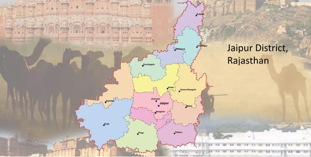
List of Tehsils in Jaipur District
Jaipur District is divided into 13 tehsils, which handle land records, local administration, and governance at the sub-district level. Each tehsil consists of multiple villages and towns.
| Tehsil | Area (km²) | Population (2011) |
|---|---|---|
| Amber | 811 | 4,52,005 |
| Bassi | 680 | 2,83,594 |
| Chaksu | 817 | 2,23,634 |
| Chomu | 681 | 3,95,009 |
| Jaipur | 579 | 22,98,782 |
| Jamwa Ramgarh | 1,022 | 3,03,236 |
| Kotputli | 811 | 4,13,256 |
| Mauzamabad | 1,340 | 2,13,016 |
| Phagi | 1,118 | 1,91,126 |
| Phulera | 1,561 | 4,44,105 |
| Sanganer | 710 | 9,69,696 |
| Shahpura | 530 | 2,72,632 |
| Viratnagar | 483 | 1,66,087 |
Villages in Jaipur District by Population
As per Census 2011, the inhabited villages of Jaipur District fall under different population brackets. The majority of villages have populations between 500 and 1,999 residents.
| Population Range | Number of Villages |
|---|---|
| Less than 200 | 134 |
| 200 – 499 | 307 |
| 500 – 999 | 651 |
| 1,000 – 1,999 | 604 |
| 2,000 – 4,999 | 341 |
| 5,000 – 9,999 | 76 |
| 10,000 and above | 13 |
This wide variation reflects the district’s mix of small rural settlements and large semi-urban villages.
Population of Jaipur District (Census 2011)
Jaipur District has a total population of 66,26,178, living in 11,77,096 households. The district shows a strong urban presence along with a significant rural population.
Population Summary
| Particulars | Total | Rural | Urban |
|---|---|---|---|
| Total Population | 66,26,178 | 31,54,331 | 34,71,847 |
| Male Population | 34,68,507 | 16,42,924 | 18,25,583 |
| Female Population | 31,57,671 | 15,11,407 | 16,46,264 |
| Total Households | 11,77,096 | 5,07,803 | 6,69,293 |
| Population Density | 595/km² | 305/km² | 4,397/km² |
Population by Age Group, Literacy & Social Category
The demographic structure of Jaipur District highlights its growing literacy levels and diverse social composition.
| Particulars | Total | Rural | Urban |
|---|---|---|---|
| Child Population (0–6 years) | 9,29,926 | 4,81,315 | 4,48,611 |
| Literate Population | 43,00,965 | 18,07,604 | 24,93,361 |
| Illiterate Population | 23,25,213 | 13,46,727 | 9,78,486 |
| Scheduled Caste (SC) | 10,03,302 | 5,29,842 | 4,73,460 |
| Scheduled Tribe (ST) | 5,27,966 | 3,93,865 | 1,34,101 |
Largest & Smallest Tehsils in Jaipur District
| Category | Tehsil |
|---|---|
| Largest Tehsil (Area) | Phulera (HQ: Sambhar) |
| Smallest Tehsil (Area) | Viratnagar |
| Most Populous Tehsil | Jaipur |
| Least Populous Tehsil | Viratnagar |